We are proud to provide a comprehensive range of services including delivery of consents and permissions, settlement of land damage claims, survey and land referencing data, agreements for lease, transfer or disposal, and arboriculture and ecology services. All directed to the goal of aiding our clients to fulfil statutory obligations and to efficiently maintain, upgrade or improve the electricity distribution system.

Securing appropriate land rights can prove both time consuming and costly. We are a specialist business consultancy focusing on energy supply requirements and the delivery of utility infrastructure projects in an efficient, timely and cost effective manner.
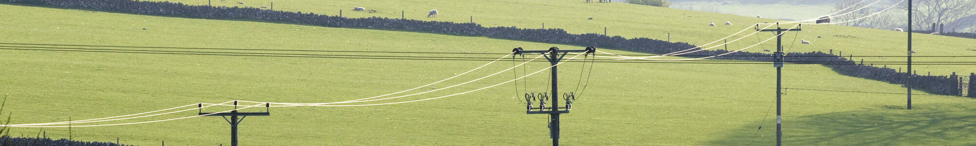
We obtain all necessary consents and permissions required by our clients to facilitate the installation, operation and maintenance of overhead lines, underground cables, substations and plant. Permissions granted both to access land and to install equipment may be documented by a wayleave agreement or, where secure rights are required, by easement/servitude.

Operating and maintaining utility distribution networks frequently requires access to be taken over land in private ownership, often during unfavourable weather conditions, resulting in unavoidable land damage. When this happens, our in-depth knowledge of agricultural and forestry practices allows us to quickly assess damage that has occurred and to provide a practical, mutually agreeable resolution, usually by way of monetary compensation in line with our client’s Land Rights policy. Such swift remediation and settlement of claims assist clients to cement and enhance close working partnerships with stakeholders.

The basis of many major projects, land referencing forms the foundation and develops throughout each project. The essential first stage is to identify the relevant parties with an interest in land affected by a proposal. Such parties may include landowners, tenants/occupiers or mortgagees. Additionally, other rights such as sporting, access rights or designated sites of historic/special interest may also be affected.
An initial assessment through a desktop study takes place in order to gather information such as detailed landownership boundaries, landowner schedules & relevant designated areas from HM Land Registry and other data sources.
In addition, to enhance clarity, our in-house CAD technician utilises industry standard software to create detailed route maps, site specific information and aerial imagery.

Measures to mitigate certain aspects of project implementation are frequently required in the life of infrastructure programs. At Bryn Mawr we have considerable experience in bringing real world solutions to bear on what otherwise appear intractable entrenched problems, which result in overcoming significant difficulties to ensure project delivery.

Powers granted by way of statutory or necessary wayleave consent, permits the holder to access land and install equipment without further the recourse to relevant landowner. Most network operators will endeavour to negotiate a voluntary agreement, however, in the event such is not achieved, network operators can often proceed to install equipment under the terms of their Operating Licence and by imposition of a statutory or necessary wayleave consent, compulsory purchase or vesting order.
What are statutory wayleaves? A statutory or necessary wayleave grants the provider the right to access land and install their equipment without the concurrence of the landowner. Most providers will try to negotiate a voluntary consent but if an agreement is not met, providers can often proceed with the install under the Code Power Operating Licence and impose Compulsory Purchase or Vesting Orders.

Frequently, determining appropriate land rights may involve acquiring land for the installation of ground mounted substation sites which can be subject to freehold transfer or leasehold agreement.
Following agreement of terms for the proposed installation, it is necessary to instruct solicitors to progress the transfer/lease a process which van take several months to complete.
Occasionally, circumstances permit the disposal of a redundant site particularly where network developments generally preclude use of the redundant site for ecological or environmental reasons.

Balancing environmental sensitivity whilst recognising the need for sustainable development plays a vital role in achieving workable solutions to complex ecology and wildlife concerns. We work closely with statutory bodies, and others, to protect and preserve our rich and diverse natural landscapes.
Bryn Mawr has a close working relationship with ecology & arboriculture consultants who we regularly commission to undertake surveys on behalf of clients. Together we work closely with customers to provide workable Construction Environment Management Plans for adoption on customer projects from the planning stage through to project completion.

Inevitably, on occasion, disputes can arise, and conflict resolution is required to mitigate what may sometimes prove to be difficult circumstances. We offer commercial advice in resolving claims related to land damage and injurious affection, and provide detailed information for recovery and/or reallocation of costs incurred by our clients in settlement of a claim.
Such close cooperation and genuine understanding of rural life are essential requirements for all of our team for continual stakeholder commitment and cooperation.
Moreover, we provide commercial advice in resolving claims related to injurious affection and land damage, providing detailed information for recovery and/or reallocation of costs incurred by our clients in settlement of claim.

Our qualified and experienced in-house surveying and CAD service utilise industry standard software to produce detailed route maps, legal plans, boundary mapping together with aerial imagery and related site-specific information. Such clear, accurate and timely technical support facilitates and enhances project viability and assists in avoiding unnecessary delays and potential misunderstandings in the progress and delivery of land rights and consents.